更多壮丽的圣海伦斯火山照片供您欣赏

我们将继续在充满精彩圣海伦斯火山照片的美国地质调查局数据库中探索

加入我们的科学爱好者社区!

本文发表于《大众科学》的前博客网络,仅反映作者的观点,不一定代表《大众科学》的观点


我仍在浏览美国地质调查局关于圣海伦斯火山的图像数据库。这需要一段时间——有近两千张图像需要分类、编目和保存。我正在 Facebook 上分享我找到的一些最好的照片:我也会在这里分享它们!

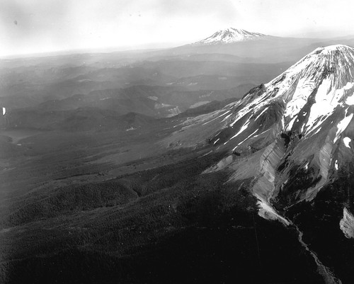
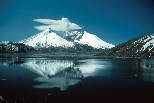
非常壮丽的圣海伦斯火山喷发前照片。务必放大观看。您会看到令人惊叹的冰川地质、倒置地形、古老的熔岩穹丘和亚当斯山。令人垂涎欲滴。务必点击查看完整图像。

Black and white image shows Mount St. Helens at the extreme right. The most prominent feature is a glacier descending from the summit, and a deep valley it carved almost all the way down the slope in colder times. Looking towards Mount Rainier in the distance, there are several ridges that look like valleys that lava flows once flowed down; the surrounding, softer material has since eroded away. Mount Rainier is visible in the background on the right.
圣海伦斯火山喷发前从东北方向的航拍图,前景为圣海伦斯火山,背景为雷尼尔山。图片和说明由美国地质调查局提供。


关于支持科学新闻

如果您喜欢这篇文章,请考虑通过以下方式支持我们屡获殊荣的新闻报道 订阅。通过购买订阅,您正在帮助确保未来能够继续讲述关于塑造我们当今世界的发现和思想的具有影响力的故事。


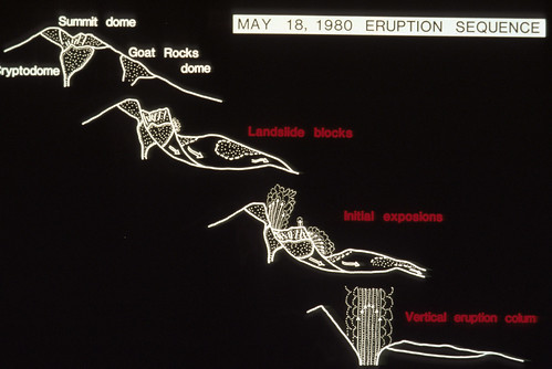
这是一个关于5月18日喷发的清晰可视化解释。

Image is a series of white line drawings on a black background, going from top left to bottom right. The first shows Mount St. Helens just before the eruption, and marks the locations of the summit dome, the cryptodome beneath it, and Goat Rocks dome on the side. The second picture shows Goat Rocks and the Cryptodome each coming down in its own landslide block. The third picture shows the landslide blocks reaching the valley, and the initial explosions emerging from the top and the side. The final drawing shows the landslide blocks resting on the valley floor, and the vertical eruption column rising from the remnants of the volcano.
J.G. Moore 绘制的简单图表,展示了 1980 年 5 月 18 日圣海伦斯火山的喷发序列。华盛顿州斯卡马尼亚县。图片和说明由美国地质调查局提供。

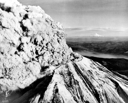
为了我的俄勒冈州的朋友们:喷发中的圣海伦斯火山,背景是胡德山。

Black and white image shows the new summit of Mount St. Helens from the northwest. You can see part of the notch the landslide and lateral blast left. A huge eruption column is pouring out of the top and bending northward. The flanks of the summit are streaked gray and black. In the distance, Mount Hood is a white triangle - its pointy top is quite distinctive.
1980 年 5 月 18 日,圣海伦斯火山喷发,向东南方向望去,远处地平线上是白雪皑皑的胡德山。华盛顿州斯卡马尼亚县。

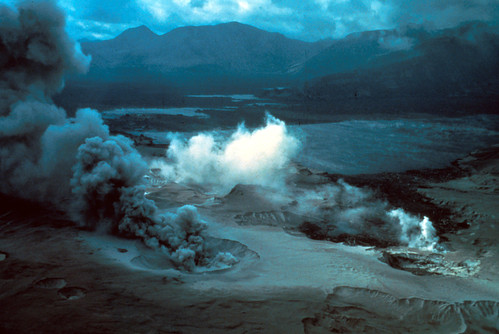
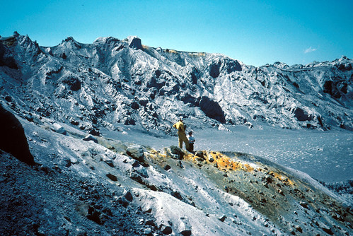
在 5 月 18 日喷发后立即拍摄的令人毛骨悚然的照片。我们正在眺望精灵湖。前景中,蒸汽从喷发沉积物中的喷气孔中喷出。

Image is looking across a plain of volcanic deposits towards mountains in the background. Everything is dark and gloomy except for the brilliant white steam plumes emerging from a crevasse in the foreground deposits. There is a crater with dark gray ash roiling from it in the center front: the ash plume is being blown toward the back left of the photo by the wind. Just beyond the plumes, scattered patches of dark water are visible in the destruction: the new Spirit Lake.
圣海伦斯火山喷发后,精灵湖的倾斜航拍图;前景是爆炸区域的次生蒸汽喷气孔。华盛顿州斯卡马尼亚县。1980年。图片和说明由美国地质调查局提供。

绝对华丽的图像,展示了 1980 年 5 月 18 日火山碎屑流上的喷气孔。

Image is taken from the base of a steep slope of mottled gray and light gray volcanic deposits, rising to a crest with boulders sticking out. Erosion has begun to cut shallow ravines int he slopes. Near the top, there are patches of harvest yellow where fumaroles have deposited sulfur: the color really pops against all that gray. The sky is deep blue with a few wispy white clouds.
圣海伦斯火山 5 月 18 日喷发的火山碎屑流上的喷气孔。华盛顿州斯卡马尼亚县。1980 年 6 月 1 日。

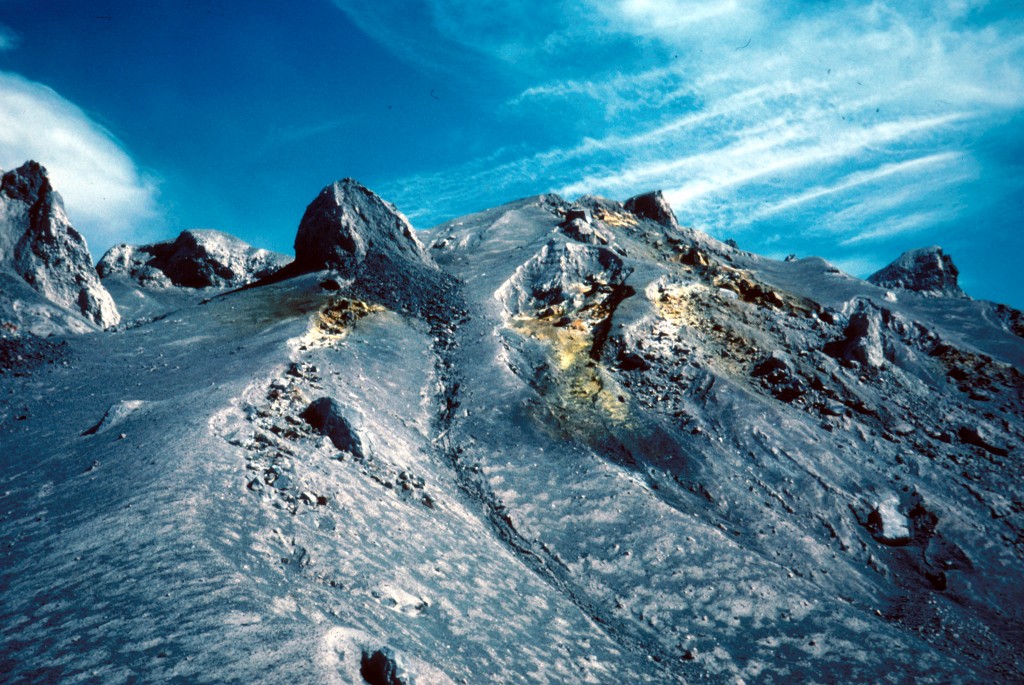
这是一个非常华丽的喷气孔,位于 5 月 18 日喷发的火山碎屑沉积物上,地质学家作为比例尺。您知道,灾难性的破坏造就了壮丽的景观。

Image shows an amphitheater ringed by rocky gray ridges. There is a touch of orange in the rim of the far ridge. In the foreground, another, lower ridge is topped with a streak of yellow-orange. Two geologists stand on top of the long orange deposit, looking down into the smooth volcanic ash scattered with logs. One has his hands on his hips.
圣海伦斯火山 5 月 18 日喷发的火山碎屑流上的喷气孔和地质学家。华盛顿州斯卡马尼亚县。1980 年 7 月 1 日。图片和说明由美国地质调查局提供。

地质学家正在观看 1980 年 8 月 7 日的喷发。我不知道你们怎么样,但在五月份发生那件事之后,如果要我站在那里拍摄火山爆发,我得花很多时间和精力鼓起勇气。

Image shows Mount St. Helens in the near distance from directly to the north, erupting a thick plume of grayish-tan ash. Two geologists stand on the ridge in front of it, filming the eruption. One is kneeling, one is standing. A case of open equipment sits between them.
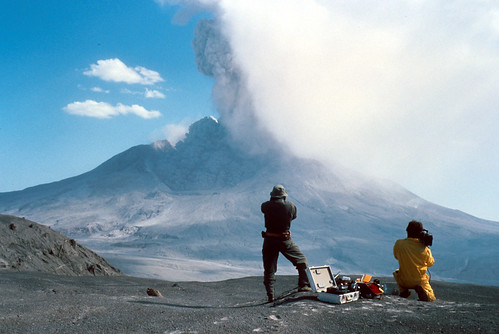
1980 年 8 月 7 日圣海伦斯火山喷发的时间推移。前景中的地质学家作为比例尺。华盛顿州斯卡马尼亚县。图片和说明由美国地质调查局提供。

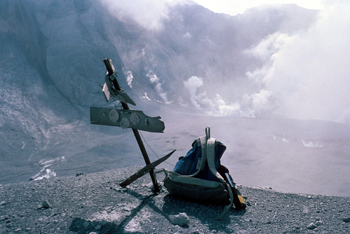
火山喷发对火山监测设备相当不利。这是 Kid Valley 大地测量目标在上方喷发过后后的样子。

Image shows a very bedraggled target: basically a post with boards nailed horizontally to it, with round reflectors attached to the boards. The top board is knocked askew and half-torn off. A chunk has been torn off the right side of the bottom board. Someone has left a backpack beside the target. In the background is a valley filled with volcanic deposits, and tall craggy ridges stripped of all life. Steam rises from the base of the ridges.
圣海伦斯火山 8 月 7 日喷发后的 Kid Valley 大地测量目标。华盛顿州斯卡马尼亚县。1980 年 8 月 9 日。图片和说明由美国地质调查局提供。

这是一张 1982 年 5 月 19 日拍摄的非常可爱的照片。您可以看到圣海伦斯火山还没有完全平静下来。照片由 Lyn Topinka 拍摄,她拍摄了许多关于这座火山的精彩照片。随着我们的深入,您将看到更多她的作品。

Image shows a snow-shrouded Mount St. Helens reflected in the calm waters of Spirit Lake. A plume of steam rises from the center of her crater: the top of it has been blown by the wind into anvil-shaped clouds close to the summit. The sky is a cloudless dark blue.
1980 年 5 月 18 日喷发两年后,圣海伦斯火山倒映在精灵湖中。华盛顿州斯卡马尼亚县。1982 年 5 月 19 日。照片由 Lyn Topinka 拍摄。图片和说明由美国地质调查局提供。

我将展示更多 1980 年 5 月 18 日之前、期间和之后的可爱照片。我还计划在本月进行一些非火山探险。我们将涉足与华盛顿州西部周围年轻地质构造截然不同的地质领域。敬请期待!


© . All rights reserved.