壮丽的圣海伦火山爆发照片,第三部分

欢迎来到我们美国地质调查局(USGS)照片数据库探险之旅的第三部分!我将继续为您奉上更多关于圣海伦火山1980年壮观苏醒的精彩照片。请欣赏!

加入我们的科学爱好者社区!

本文发表于《大众科学》的前博客网络,反映了作者的观点,不一定代表《大众科学》的观点


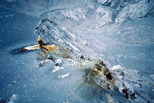
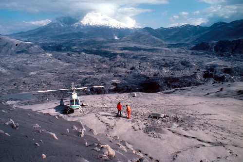
喜欢这张照片的角度,它展现了穿越火山碎屑流和喷气孔,望向凹陷处的景象。所有生物都已死亡并被掩埋,地质学家看起来像是在另一个星球上的宇航员。

Image shows a gray volcanic terrain. There is part of a crater in the photo, making it look like it was taken on the moon. A geologist dressed in yellow stands beside the yellow-orange stains of a fumarole on the edge of the crater.
地质学家和喷气孔,位于1980年5月18日圣海伦火山爆发的火山碎屑流上。斯卡马尼亚县,华盛顿州。1980年7月1日。公共领域图像和说明由美国地质调查局提供。


关于支持科学新闻报道

如果您喜欢这篇文章,请考虑通过以下方式支持我们屡获殊荣的新闻报道: 订阅。通过购买订阅,您正在帮助确保关于塑造我们当今世界的发现和思想的具有影响力的故事能够拥有未来。


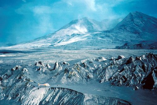
从火山碎屑流对面看到的圣海伦火山,拍摄于5月18日爆发后不久。那里也有一架直升机。

Image shows a steaming Mount St. Helens. In the middle of the photo are jagged hummocks looking like a mini-mountain range. A helicopter is parked in front of them on the edge of a crater, dwarfed by their size.
从西北方向看到的1980年5月18日圣海伦火山爆发的火山碎屑流。背景是圆形剧场状的山谷。前景是火山流边缘的直升机。斯卡马尼亚县,华盛顿州。1980年7月1日。公共领域图像和说明由美国地质调查局提供。

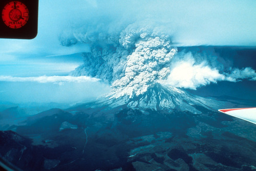
我们通常看到的是普林尼式火山爆发柱。你知道,那种漂亮的垂直柱状,高耸入大气层,看起来非常壮观。但是当扇形崩塌在新火山口边缘留下巨大的缺口时,物质就会横向喷发。这张照片显示了由此产生的火山灰墙向北咆哮而去的景象。真是令人惊叹。

Image shows Mount St. Helens erupting. There is a bit of airplane wing visible at the middle-right. The dark gray Plinian eruption column califlowers up into to sky; part of it is marching out to the north, forming a wall of ash along the ground.
1980年5月18日圣海伦火山爆发,从南方拍摄。摄影:J.G. Rosenbaum。斯卡马尼亚县,华盛顿州。公共领域图像和说明由美国地质调查局提供。

这就是火山灰覆盖你的房子后的样子。这东西绝对是清理起来的灾难。

Image shows a man in a pale shirt and black pants, standing on his roof and sweeping ash over the edge. The ash is falling in a curtain like a waterfall. Beside it is his ladder. In front of it are some ash-covered bushes.
华盛顿州东部居民正在清扫1980年5月18日圣海伦火山爆发后屋顶上的火山灰。华盛顿州。1980年5月18日之后。《美国地质调查局》第17页下方的照片。《圣海伦火山爆发:过去、现在和未来》,作者:Robert I. Tilling。1984年。公共领域图像和说明由美国地质调查局提供。

给你们来一张可爱的前后对比照。这是靠近A1 Rought公园的北图特尔桥。你可以看到它是一个相当坚固的金属结构——或者至少在火山泥流袭击它之前是。你可能需要放大才能在泥浆中看到它扭曲的残骸。

Image on the left shows a typical Northwest bridge, which has a green steel framework over it. Image on the right shows a sea of mud with the twisted remains of the steel frame stuck in.
两张美国地质调查局图像的前后合成图:左图:1980年5月18日圣海伦火山爆发前,靠近A1 Rought公园的北图特尔桥。向北看。摄影:D.R. Crandell。考利茨县,华盛顿州。1980年4月。右图:1980年5月18日圣海伦火山爆发后的阿尔·劳特桥。摄影:D.R. Crandell。考利茨县,华盛顿州。1980年5月24日。公共领域图像和说明由美国地质调查局提供。

既然你们都喜欢看火山爆发对车辆的影响,那就看看圣海伦火山对这辆韦尔豪瑟巴士做了什么。

Image shows a school-type bus buried up to its hood in mud, with a screen of trees behind it. The top is dusted with ash. Some of the windows are shattered, and it's dented and sandblasted. The letters WEYERHAUSER COMPANY are just visible under mud spatters beneath the windows, and above the windows is cursive writing are the words
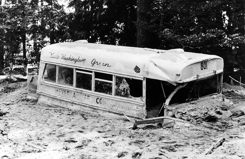
韦尔豪瑟公司员工巴士被1980年5月18日圣海伦火山爆发严重损坏,并部分被北图特尔河靠近贝克营的泥流掩埋。巴士被泥流袭击时无人乘坐。考利茨县,华盛顿州。1980年。《美国地质调查局专业论文1250》图409。公共领域图像和说明由美国地质调查局提供。
Image shows a hollowed-out, snowcapped Mount St. Helens brooding in the distance. The North Fork Toutle River valley is visible, covered in hummocks from the debris avalanche and mud from the lahars. In the foreground is an ash-covered slope spilling down to a flat gray-brown area. The hood of a car is just visible, buried in the volcanic deposits. A helicopter is parked nearby. Two men in bright red jumpsuits stand near the car, staring down at the deposits.
从科尔德沃特一号向东看,是1980年5月18日圣海伦火山爆发后的科尔德沃特二号山脊。考利茨县和斯卡马尼亚县,华盛顿州。1980年5月23日。公共领域图像和说明由美国地质调查局提供。

噢噢,真棒。各位,我们不常看到断层在我们自己的脚印中形成,但我们现在看到了!

Image shows a hiking boot imprint in ash deposits. A small fumarole has spilled yellow-orange deposits over the tip. Diagonal cracks have formed in the deposits, cutting across the print.
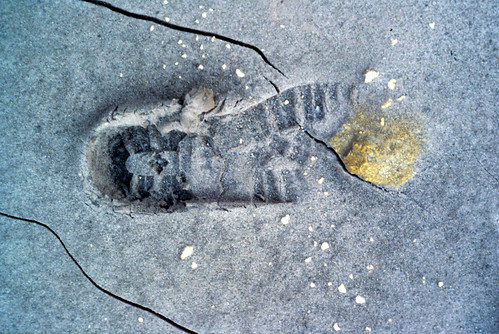
圣海伦火山爆发前形成的裂缝。1981年1月9日留下的脚印在几天后开裂。脚印就在逆冲断层的前面。斯卡马尼亚县,华盛顿州。1981年1月。公共领域图像和说明由美国地质调查局提供。

本期就到这里,请继续关注——我还有更多精彩内容!


© . All rights reserved.